Sub-Total: $0.00

The Roads in the Sky: Understanding North America’s Four Flyways
It was an ordinary afternoon in central Texas when it landed.
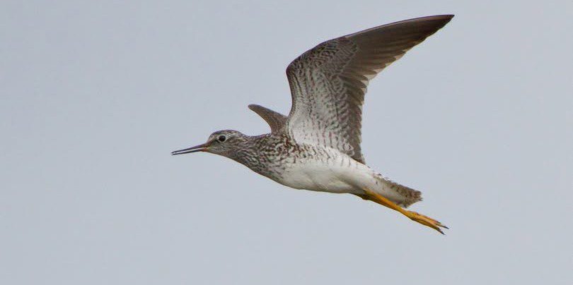
A Lesser Yellowlegs — slim, elegant, picking its way along the pebbly edge of a Granger Lake like it had all the time in the world. But it didn’t. This bird was in the middle of one of the most extraordinary journeys on earth.
I watched it through my binoculars and thought about where it had been. Somewhere in Central or South America, riding out the winter in a warm coastal wetland thousands of miles from here. And where it was going — the boreal forests of Alaska or Canada, a breeding ground it had likely never seen this year but would find anyway, guided by instinct, stars, and magnetic fields we can barely comprehend.
Central Texas was just a gas station. A rest stop on a route that makes Interstate 35 look modest.
That bird is why I find flyways so fascinating. And why understanding them will change the way you look at every bird that passes through your yard.
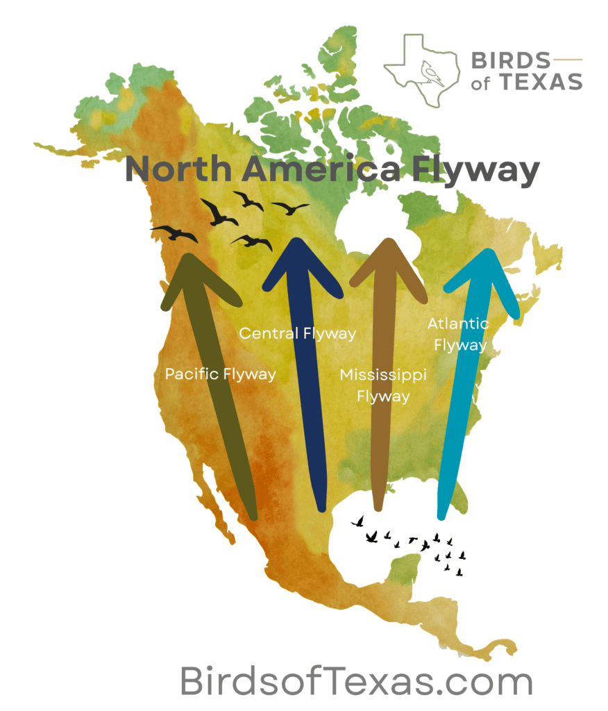
What Is a Flyway?
A flyway is a broad migration corridor — a geographic route that birds follow between their wintering grounds and their breeding grounds each year. Think of them as river systems in the sky: wide, somewhat loosely defined, but consistently followed generation after generation.
North America has four official flyways, each named for a major geographic feature along its path:
The Atlantic Flyway. Running along the Eastern Seaboard from the arctic tundra down to the Caribbean and South America, the Atlantic Flyway carries an enormous diversity of shorebirds, waterfowl, and songbirds along the coast. Delaware Bay is one of its most famous stopovers — every spring, Red Knots time their migration precisely to coincide with horseshoe crab spawning, refueling on eggs before pushing on to the Arctic.
The Mississippi Flyway. The mighty Mississippi River and its tributaries form a natural funnel for migration, and the flyway that follows it is arguably the most important on the continent. Billions of birds funnel through it each year. The bottomlands of Louisiana, the marshes of the Great Lakes, the prairies of Illinois — all critical links in a chain that stretches from the Gulf to the tundra.
The Central Flyway. Stretching down through the Great Plains from Canada to the Gulf of Mexico, the Central Flyway is home to some of North America’s most spectacular migration events. Sandhill Cranes staging along the Platte River in Nebraska — half a million birds in a single stretch of river — is one of the great wildlife spectacles left on this planet.
The Pacific Flyway. Following the Pacific Coast and the mountain ranges of the West, the Pacific Flyway carries millions of waterfowl, shorebirds, and raptors along one of the most scenic routes on earth. The Klamath Basin on the Oregon-California border is a critical stopover for waterfowl. The Marin Headlands in California — a famous hawk watch site anchored by this flyway.
Texas: The Crossroads
Here’s what makes Texas extraordinary for birders: we sit right at the intersection of the Central Flyway and the edge of the Mississippi Flyway. Birds from the eastern half of the continent and the western half both pass through our skies.
The Gulf Coast acts as a concentration point. Migrants crossing the Gulf of Mexico — a non-stop flight of 500 to 600 miles — make landfall along the Texas coast exhausted and desperate to feed. On mornings after a cold front, when the wind shifts north and grounds thousands of birds at once, the trees along High Island and Bolivar Flats fill up like something from a dream. Warblers stacked ten deep in a single live oak. Thrushes everywhere you look. Tanagers and grosbeaks dropping out of the sky.
We see it inland too. Lakeside parks, wooded creek bottoms, brushy fence lines — anywhere migrants can rest and refuel becomes a hotspot during peak migration. In Williamson County alone, the spring checklist reads like a greatest hits of North American bird diversity.
That lake where I found my Lesser Yellowlegs this week? It barely registers on a map. But to that bird, it was everything. A safe place to rest, to eat, to prepare for the next leg of a journey measured in continents.
When Do They Move?
Migration in Texas happens in two main pulses:
Spring (March through May) is northbound migration. The pace builds from mid-March and peaks in late April through mid-May. Neotropical migrants — warblers, vireos, orioles, tanagers, buntings — are moving with urgency, driven by the need to reach breeding grounds and stake out territory.
Fall (August through November) is southbound migration. It’s a longer, more leisurely affair. Young birds that have never migrated before are finding their way for the first time. The pace stretches out, and the diversity can be extraordinary — species that are easy to miss in spring may linger for days in fall.
Why Flyways Matter Beyond Birding
The flyway concept isn’t just useful for planning your next birding trip. It’s the foundation of North American migratory bird conservation.
Waterfowl management is organized around flyways. The four Flyway Councils — Atlantic, Mississippi, Central, and Pacific — each include representatives from U.S. states, Canadian provinces, and Mexican states, working together to manage hunting regulations and habitat across the entire corridor. It’s one of the most successful multinational wildlife management frameworks in history.
But the system is under pressure. Wetlands are drained. Stopover habitats are developed. Pesticide use reduces insect food supplies. Climate fluctuations shift the timing of insect emergence, disrupting the precise synchronization that migrants have evolved over millennia.
Every habitat conserved along a flyway — every wetland preserved, every native meadow left unmowed — matters to billions of birds. Not just the ones in your county. Billions.
How to Use Flyways as a Birder
Once you understand flyways, a few things click into place:
Timing matters. Learn the peak migration windows for your region and be out there. The difference between a quiet walk and a morning you’ll talk about for years is often just showing up during peak passage.
Geography matters. Peninsulas, lakeshores, and river valleys concentrate birds. The tip of a peninsula with favorable wind becomes a migrant trap. Learn the concentration points along your section of the flyway.
Weather matters. Birds move on favorable tailwinds and get grounded by headwinds. A cold front in spring stops migration — then the morning after, when the front passes and the wind shifts, birds pour through. Check the forecast. Know when to go.
eBird is your roadmap. The Cornell Lab’s real-time eBird data shows you where birds are moving right now, along every flyway, every day of the year. Use it. It’s extraordinary.
The Last Look
Before I left that afternoon, I watched the Lesser Yellowlegs one more time. Grabbed a photo.
It had no idea I was there. No idea that I’d been standing in the north winds for twenty minutes just to watch it feed. It bobbed its head, picked at something in the mud, and went about the ancient business of surviving a 6,000-mile journey.
By the time you read this, it’s probably already in Canada. Finding its territory. Beginning to breed. Living a life so far from that central Texas reservoir that the two places seem impossible to connect — and yet connected they are, as surely as the flyway that links them.
We share this sky with billions of birds making billions of journeys. All we have to do is look up.
Happy birding, Texas. 🦅